Selected Villages- Qanawaat

Qanawaat
Qanawaat, also known as Kanatha or Kanatha, is a town in Syria, located 7 km northeast of the city of As-Suwayda, in the Jabal al-Arab region at an altitude of 1200 meters above sea level, amidst forested mountains. It is an ancient city, considered one of the most famous Roman archaeological sites, and was formerly one of the cities of the Decapolis.[2][3][4] Its population was 8324, according to the 2004 census issued by the Syrian Central Bureau of Statistics.[5]
History
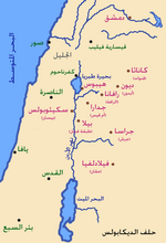
The Decapolis map shows the location of Kanatha (Qanawat)
Qanawat, or Kanatha, is one of the most important Roman archaeological sites in the Eastern Roman Empire, and it was one of the cities of the Decapolis League. Historically, Qanawat was known as Kanatha or Kanatha. It contains many Roman and Byzantine ruins and was a religious episcopal center that attracted Christian pilgrims in the 7th century AD, holding significant religious importance and sanctity.
Hellenistic and Roman History
The ancient Hellenistic Roman city of Canata (Κάναθα in Greek) was first mentioned during the reign of Herod I (1st century BC) when Nabataean Arab forces defeated a Jewish army. It remained a point of contention between the two powers. From the time of Pompey the Great until Trajan, it was a city of the Decapolis, a loose federation of cities that the Romans allowed a degree of autonomy. In the 1st century AD, it was incorporated into the Roman province of Syria, and in the 2nd century, it was renamed Septimia Canata by Septimius Severus and became a Roman colony, transferred to the province of Arabia Petraea. Episcopal See
Only one of the bishops of Kanatha is known by name: Theodosius participated in the Council of the Robbers at Ephesus in 449, the Council of Chalcedon in 451, and the Synod convened by Patriarch Gennadius I of Constantinople in 459 against simony.
Kanatha is no longer a resident bishopric; today it is listed by the Catholic Church as a title see.[9]
Early Islamic Period
Kanatha was a center of Christianity in the region. It was captured by the Muslims in 637 and declined in importance until the 9th century CE, becoming a poor village.
Ottoman Period
Qanawat in 1900, from the Gertrude Bell Archives
In 1596, Qanawat appeared in Ottoman tax records as part of the Banu Nasiya district of the Sanjak of Hauran. Its population consisted of twelve Muslims and five Christian families. Among the inhabitants were a group of settled Bedouin. The villagers paid a fixed tax rate of 20% on various agricultural products, including wheat, barley, summer crops, goats, and beehives; a total of 4,750 akçe. Qanawat was abandoned between the 17th and 18th centuries. However, by the 1820s, it was one of the first villages in the Jabal Hauran to be repopulated by Druze migrants from Mount Lebanon. At that time, five or six Druze families had settled in the village. Due to its Roman past, Qanawat already had paved roads, vacant houses, and readily available water sources. However, its population only gradually increased between 1830 and 1850. Although it became home to Druze religious leaders during this period, it was not until the 1850s that it was established as the seat of the prominent Sheikh al-Aql (Druze religious leader) and a center of local Druze politics. Following further Druze migration to the region after the 1860 Druze-Maronite massacre, Qanawat grew into a large village.
The first Sheikh al-Aql of Qanawat was Ibrahim al-Hajri, who played a key role in mobilizing Druze resistance against the conscription orders of the Egyptian governor Ibrahim Pasha in the late 1830s. Ibrahim died in 1840 and was succeeded by his son Hussein. At that time, Qanawat was under the control of the Hamdan family, the main Druze clan in Hauran. However, under Hussein’s leadership, the Hajri family formed the Sheikhdom of the Aql, which gradually became the main religious institution recognized by the Druze of Hauran. The Hamdan family used it to consolidate their influence among the Druze, but they lost Qanawat to the Atrash clan in the 1860s. The Atrash clan nominally controlled the canals, with the Hajri family managing village affairs independently through the Sheikhdom of the Druze community.
Main Tourist Attractions
The extensive ruins of the ancient city are approximately 1,500 meters long and 750 meters wide. They include a Roman bridge, a rock-cut theater with nine rows of seats and a nineteen-meter-diameter orchestra pit, a nymphaeum, a Roman aqueduct, and a large temple with a portico and columns. Located northwest of the city, it dates from the late 2nd or early 3rd century and was built on a high platform surrounded by a portico. For years, this temple was thought to honor Helios, but a 2002 inscription revealed it was dedicated to the local deity, Rabbus.
The monument known as the Saraya dates from around the 2nd century AD. Originally a temple, it later became a Christian basilica in the 4th and 5th centuries. It is 22 meters long and is preceded by an outer portico and a hall with eighteen columns. The German explorer Hermann Burchardt visited the city in 1895 and photographed its ruins. These photographs are now preserved in the Ethnological Museum in Berlin.
The city of Qanawat is very rich in ruins, many of which still stand today. These include numerous royal buildings, temples, squares, roads, and much more. The city is divided into two parts:
The first part: The upper part of the city and the historical city of Qanatha. This area dates back to the pre-Iron Age I and consists of high walls, flat blocks, and stone terraces containing several temples, such as the Temple of Zeus and the terrace temples. The largest temple is located in the western palace and consists of a sanctuary, an altar, and three domes. This part also contains the basilica area, which was used for trade, administrative buildings, walls, and cisterns.
Section Two
This section includes the valley, the theater, the Temple of the Water Goddess, a sophisticated underground aqueduct system, and monastic buildings dating back to the 1st century BC. This part of the aqueduct also contains Roman baths, water reservoirs, and numerous other archaeological structures.
Landmarks of the Canals/Kanatha
Temple of Helios (Sun Goddess),
Temple of Zeus,
Temple of Athena (Goddess of Wisdom),
Temple of the Lamethymium (Goddess of Water),
Roman Theater,
Odeon,
Churches/Basilicas,
Important Roman Baths,
Official Buildings,
Water Reservoirs,
Aqueducts,
Gates,
Wall,
Tombs,
Towers
قنوات
أو كاناثا أو كانثا هي بلدة في سورية، تقع على بعد 7 كم شمالي شرق مدينة السويداء، في منطقة جبل العرب على ارتفاع 1200 متر عن سطح البحر وسط الجبال التي تغطيها الغابات، وهي مدينة أثرية تعد من أشهر المدن الأثرية الرومانية، وكانت سابقا إحدى مدن الديكابلوس.[2][3][4] بلغ عدد سكانها 8324 نسمة، وذلك وفقا لتعداد عام 2004، الصادر عن المكتب المركزي للإحصاء السوري.[5]
تاريخ
تعد قنوات أو كاناثا واحدة من أهم المدن الأثرية الرومانية في الإمبراطورية الرومانية الشرقية، وهي من مدن حلف الديكابولس، تاريخيا كانت القنوات تعرف باسم كانثا أو كاناثا. يوجد بها الكثير من الآثار الرومانية والبيزنطية، وهي مركز أسقفي ديني كان يحج إليه المسيحيون في القرن السابع الميلادي، ولها قداستها وأهميتها الدينية.
التاريخ الهلنستي والروماني
تم ذكر مدينة كاناتا الرومانية القديمة الهلنستية (Κάναθα في اللغة الإغريقية)، لأول مرة في عهد هيرودس الأول (القرن الأول قبل الميلاد)، عندما هزمت القوات العربية النبطية جيشًا يهوديًا. ظلت مسألة خلاف بين القوتين. من وقت بومبيوس الكبير حتى تراجان، كانت مدينة ديكابوليس، وهي اتحاد فضفاض للمدن سمح له الرومان بالتمتع بدرجة من الحكم الذاتي. في القرن الأول الميلادي تم ضمّها إلى مقاطعة سوريا الرومانية، وفي القرن الثاني أعيدت تسميتها باسم «سبتيميا كاناثا» بواسطة سيبتيموس سيفيروس، وأصبحت مستعمرة رومانية، وتم نقلها إلى مقاطعة العربية البترائية.
الأسقفية
واحد فقط من أساقفة كاناثا معروف بالاسم: شارك ثيودوسيوس في مجمع اللصوص في أفسس عام 449، وفي مجمع خلقيدونية عام 451، وفي سينودوس دعا إليه البطريرك غناديوس الأول القسطنطيني عام 459 ضد السيمونية.
لم تعد كاناثا أسقفية سكنية، فقد تم إدراجها اليوم من قبل الكنيسة الكاثوليكية ككرسي لقبي.[9]
العصر الإسلامي المبكر
كانت كاناثا مركزًا للمسيحية في المنطقة، وقد استولى عليها المسلمون في عام 637، وانخفضت أهميتها حتى القرن التاسع الميلادي، حيث تحولت إلى قرية فقيرة.
العصر العثماني

في عام 1596، ظهرت قنوات في سجلات الضرائب العثمانية كجزء من ناحية بني ناصية من سنجق حوران. كان عدد سكانها اثني عشر مسلمًا وخمسة أسر مسيحية. وكان من بين السكان مجموعة من البدو المستقرين. دفع القرويون معدل ضريبة ثابتًا قدره 20٪ على المنتجات الزراعية المختلفة، بما في ذلك القمح والشعير والمحاصيل الصيفية والماعز وخلايا النحل؛ ما مجموعه 4750 آقجة. تم التخلي عن القنوات بين القرنين السابع عشر والثامن عشر. ومع ذلك، بحلول عشرينيات القرن التاسع عشر، كانت من أولى القرى في جبل حوران التي أعاد المهاجرون الدروز من جبل لبنان إعمارها.. في ذلك الوقت، استقرّت في القرية خمس أو ست عائلات درزية. وبسبب ماضيها الروماني، كان للقنوات بالفعل ممرّات معبدة ومنازل خالية، ومصادر مياه متاحة بسهولة. ومع ذلك، فقد زاد عدد سكانها بشكل تدريجي فقط بين عامي 1830 و1850. على الرغم من أنها أصبحت خلال تلك الفترة موطنًا لشيوخ الدين الدروز، إلا أنه لم يتم تأسيسها حتى خمسينيات القرن التاسع عشر كمقر لشيخ العقل البارز (الزعيم الديني الدرزي)، ومركزًا للسياسة الدرزية المحلية. بعد المزيد من الهجرة الدرزية إلى المنطقة بعد مقتلة الدروز والموارنة 1860، نمت القنوات لتصبح قرية كبيرة.
شيخ العقل الأول للقنوات هو إبراهيم الهاجري، الذي لعب دورًا رئيسيًا في حشد مقاومة الدروز لأوامر التجنيد الإجباري للحاكم المصري إبراهيم باشا، في أواخر ثلاثينيات القرن التاسع عشر. توفي إبراهيم عام 1840، وخلفه ابنه حسين. كانت القنوات في ذلك الوقت تحت سيطرة آل حمدان، العشيرة الدرزية الرئيسية في حوران. ومع ذلك، تحت قيادة الحسين، شكّلت عائلة الهاجري مشيخة العقل، والتي أصبحت تدريجياً المؤسسة الدينية الرئيسية المعترف بها من قبل دروز حوران. استخدمها آل حمدان لتعزيز نفوذهم بين الدروز، لكنهم فقدوا القنوات لصالح عشيرة الأطرش في ستينيات القرن التاسع عشر. كانت الأطرش تُسيطر اسميًا على القنوات فقط، مع إدارة عائلة الهاجري لشؤون القرية بشكل مستقل من خلال مشيخة العقل
المعالم السياحية الرئيسية
يبلغ طول أطلال المدينة القديمة الواسعة حوالي 1500 متراً، وعرضها 750 متر. يوجد بها جسر روماني ومسرح منحوت في الصخر، به تسعة صفوف من المقاعد وأوركسترا يبلغ قطرها تسعة عشر متراً، وأيضاً نيمفيوم وقناة رومانية، ومعبد كبير مع رواق وأعمدة. يقع شمال غرب المدينة في أواخر القرن الثاني أو أوائل القرن الثالث، وقد تم بناؤه على منصة عالية محاطة برواق. لسنوات، كان يُعتقد أن هذا المعبد يكرّم هيليوس، ولكن تم اكتشاف نقش عام 2002 يُظهر أنه كان مخصصًا للإله المحلي رابوس.
يعود تاريخ النصب التذكاري المعروف باسم «السرايا» إلى حوالي القرن الثاني الميلادي، وقد كان في الأصل معبدًا، ومن ثم، أصبح بازيليكا مسيحية في القرنين الرابع والخامس. يبلغ طوله 22 متراً، ويسبقه رواق خارجي وردهة بها ثمانية عشر عمودًا.
زار المستكشف الألماني هيرمان بورخارت المدينة في عام 1895، والتقط صوراً لآثارها، والصور الفوتوغرافية محفوظة الآن في المتحف الإثنولوجي في برلين [الإنجليزية].
آثار
مدينة قنوات غنية جدا بالآثار التي ما زال الكثير منها قائما حتى اليوم وتتمثل في الكثير من الأبنية الملكية والمعابد والساحات والطرقات والكثير الكثير وتنقسم المدينة إلى قسمين:-
القسم الأول
جزء المدينة الأعلى ومدينة كاناثا التاريخية ويعود استعمال هذه المنطقة إلى ماقبل العصر الحديدي الأول وهو عبارة عن أسوار عالية وبلوكات منبسطة وتراسات حجرية تضم عدة معابد مثل معبد زيوس ومعابد التراسات ويوجد أكبر معبد في السراي الغربي ويتكون المعبد من قدس الأقداس ومن مذبح وثلاثة قباب، ويوجد في هذا الجزء منطقة (البازليك) التي كانت تستعمل للتجارة ومباني إدارية والأسوار والخزانات.
القسم الثاني
ويضم هذا القسم الوادي والمسرح ومعبد إلهة المياه وشبكة من أقنية المياه تحت الأرض بنظام متطور ومباني أديرة بنيت في القرن الأول قبل الميلاد، ويوجد في هذا الجزء من قنوات معبد وحمامات رومانية وخزانات للمياه إضافة إلى مباني أثرية عديدة.
معالم قنوات / كاناثا
- معبد هليوس – إلهة الشمس
- معبد زيوس
- معبد إلهة الحكمة – آثينا
- معبد اللمثيميوم – إلهة المياه
- المسرح الروماني
- الأوديون
- الكنائس / البازليك
- الحمامات الرومانية الهامة
- المباني الرسمية
- خزانات المياه
- أقنية المياه
- البوابات
- السور
- المدافن
- الأبراج